 BoreTherm
Site background calibration
Choose two known points and their real separation to scale a background plan. Set origin and orientation consistently with borehole coordinates. Check another known dimension afterward; calibration cannot correct perspective distortion.
Step-by-step workflows · Menus and keyboard
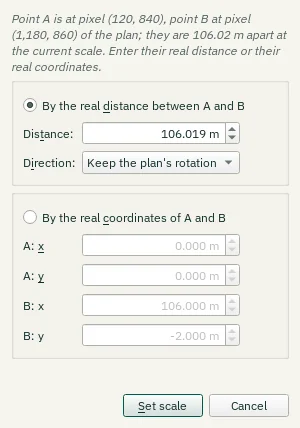
| Control | Meaning / action | Unit | Range / choices | Example value |
|---|---|---|---|---|
| By the real distance between A and B | Selects this alternative. | |||
| Distance: | Distance between the two points in reality, e.g. a dimension written on the plan. | m | 0.001 to 1e+06 | 106.019 |
| Direction: | Rotates the plan so that the line from A to B points east or north, e.g. along a property line or a north arrow drawn on the plan. Point A keeps its position. | Keep the plan's rotation / A → B points east (+x) / A → B points north (+y) | ||
| By the real coordinates of A and B | Selects this alternative. | |||
| A: x | x (east) of point A in the site frame. | m | -1e+07 to 1e+07 | 0 |
| A: y | y (north) of point A in the site frame. | m | -1e+07 to 1e+07 | 0 |
| B: x | x (east) of point B in the site frame. | m | -1e+07 to 1e+07 | 106 |
| B: y | y (north) of point B in the site frame. | m | -1e+07 to 1e+07 | -2 |
| Set scale | Apply the drawing scale calculated from the selected calibration points and known distance. | |||
| Cancel | Close without accepting unapplied edits. | |||
| Distance: | Distance between the two points in reality, e.g. a dimension written on the plan. | ft | 0.003 to 3.28084e+06 | 347.831 |
| A: x | x (east) of point A in the site frame. | ft | -3.28084e+07 to 3.28084e+07 | 0 |
| A: y | y (north) of point A in the site frame. | ft | -3.28084e+07 to 3.28084e+07 | 0 |
| B: x | x (east) of point B in the site frame. | ft | -3.28084e+07 to 3.28084e+07 | 347.769 |
| B: y | y (north) of point B in the site frame. | ft | -3.28084e+07 to 3.28084e+07 | -6.562 |